Keanakakoi Crater Overlook is the closest you can walk to an erupting Kilauea Volcano, a viewpoint on the edge of Halema’uma’u Crater that you reach on foot along a closed road in Hawaii Volcanoes National Park. The walk is only 2 miles round trip, yet it puts you about a mile from the lava.
Keanakakoi Crater Overlook is a viewpoint above Keanakākoʻi Crater, a 115-foot-deep pit crater whose name means “cave of the adzes” in Hawaiian. Ancient Hawaiians quarried basalt here to make adze heads, the cutting tools of their time.
This guide covers the Keanakakoi Crater Overlook in 2026: the walk from the Devastation Trailhead, the crater’s history, the lava views, and the practical details — fees, parking, best time, and safety rules.
By Great Hawaii Tour — your guide to Hawaii tours and island adventures.
Key Points
- Keanakakoi Crater Overlook is the closest public viewpoint to Halema’uma’u Crater, about 1 mile from the erupting vent.
- Keanakākoʻi means “cave of the adzes” — an ancient Hawaiian quarry for basalt adze heads, buried by lava in 1877 and 1974.
- The walk is 2 miles round trip from the Devastation Trailhead, on a closed section of Old Crater Rim Drive, and takes 1 to 1.5 hours.
- The crater is about 115 feet deep and about 250 yards across, formed when the Kilauea summit collapsed in the 1400s.
- Park entry is $30 per private vehicle, valid for 7 days, and the park is open 24 hours a day.
- Visit at night during an eruption for the lava glow — but expect crowds between 8 and 11 p.m.
What Is Keanakakoi Crater Overlook?
Keanakakoi Crater Overlook is a fenced viewpoint on the southeastern side of Kilauea caldera, looking into Keanakākoʻi Crater and across to Halema’uma’u Crater. It is the closest the public can currently get to Halema’uma’u, the crater where Kilauea’s lava erupts.
Keanakākoʻi Crater is a pit crater, a steep-sided hole left when the ground above a drained magma chamber collapsed. It formed during summit collapses in the 1400s, and its floor is about 115 feet below the rim.
The crater’s name records its old use. Ancient Hawaiians quarried dense basalt from its walls to shape adze heads, the axe-like tools used to carve canoes and houses. Lava buried the quarry in 1877, and a fissure eruption buried it again in July 1974.
The Walk: Devastation Trailhead to the Overlook
Park at the Devastation Trailhead lot, at the junction of Crater Rim Drive and Chain of Craters Road. Walk back to the junction, then head west past the road barrier onto the closed section of Old Crater Rim Drive.
The walk is about 1 mile each way on cracked, mostly paved road through koa and ʻōhiʻa forest, with about 100 to 130 feet of gentle elevation change. Keanakākoʻi Crater appears on your left after roughly 0.9 miles.
A short spur trail of about a quarter mile leads to the fenced overlook, past fissures where steam escapes from cracks in the ground. Stay inside the fenced area — the ground beyond it is closed for safety.
Bikes are allowed on the closed road but not on the spur trail, and dogs are not allowed anywhere on the walk. No permit is needed, but the $30 park entry fee applies.
Great Hawaii Tour tip: start the walk in the late afternoon and stay for sunset, when the light turns the caldera gold and the lava glow takes over as darkness falls. Great Hawaii Tour recommends checking the USGS volcano update that morning, since lava is only visible during an eruptive episode.
Best Lava Viewing in Hawaii Volcanoes National Park
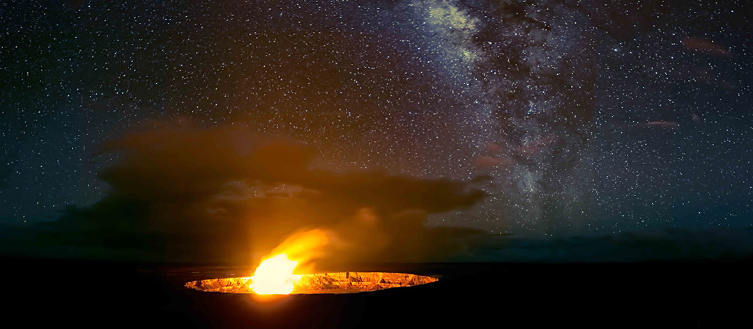
When Kilauea is erupting, the Keanakakoi Crater Overlook is the best place in the park to watch it. Halema’uma’u Crater sits about a mile away, close enough to see lava fountains and the glow on the crater walls on a clear night.
Night is when the overlook earns its reputation. The glow is strongest after dark, and hundreds of people can gather here on a big eruption night, lining the fence to watch fountains rise and fall.
Arrive before 8 p.m. if you can, since the Devastation lot fills fast during peak viewing hours. Bring a headlamp for the walk back — the road is pitch dark after sunset — and dress warmly, since the summit sits near 4,000 feet.
What Else to See Nearby
The Devastation Trail starts from the same parking lot, a paved 1-mile round trip through a stark landscape buried by cinder from the 1959 Kilauea Iki eruption. It takes about an hour and pairs well with the overlook walk.
The Steam Vents and Sulphur Banks sit a short drive west on Crater Rim Drive, where steam hisses from cracks in the ground and volcanic gases stain the rock yellow. The Kilauea Overlook, a short walk from its own parking lot, gives the wide view of the caldera.
Nahuku, the Thurston Lava Tube, is a 500-year-old cave you can walk through, lit from 8 a.m. to 8 p.m. Allow 20 to 30 minutes, and expect its small car park to fill by midday.
How to Reach, Facilities, and Planning Tips
Open Time
| Day | Timing |
|---|---|
| Monday | Open 24 hours |
| Tuesday | Open 24 hours |
| Wednesday | Open 24 hours |
| Thursday | Open 24 hours |
| Friday | Open 24 hours |
| Saturday | Open 24 hours |
| Sunday | Open 24 hours |
The park never closes, so you can walk to the Keanakakoi Crater Overlook at any hour. The Welcome Center at Kilauea Military Camp is open daily from 9:00 a.m. to 4:45 p.m.
Best Time to Visit
Night during an eruption is the best time to visit the Keanakakoi Crater Overlook, when the lava glow is visible from the viewpoint. By day, early morning gives the softest light and the thinnest crowds.
Check the USGS Hawaiian Volcano Observatory update on the morning of your visit. Kilauea has erupted in episodes since December 23, 2024, and lava is only visible during an episode, so treat a sighting as a bonus, not a promise.
By Road
The park entrance is off Highway 11, about 30 miles and 45 minutes from Hilo, and about 95 miles and 2 to 2.5 hours from Kailua-Kona. Drive Crater Rim Drive to its junction with Chain of Craters Road and park at the Devastation Trailhead lot.
The lot has 58 stalls and fills by mid-morning on busy days, and faster still on eruption nights. Entry is $30 per private vehicle, valid for 7 days, and the park is cashless, so bring a card.
By Air
The nearest airport is Hilo International Airport (ITO), about 45 minutes from the park. Kona International Airport (KOA) is the other option, about 2 to 2.5 hours away by road.
Nearby Bus Stand
There is no public bus service into the park, so most visitors arrive by rental car or on a guided tour. If you are staying in Hilo without a car, book a tour that includes park transport.
Destination Facilities
Restrooms are available at the Devastation Trailhead parking lot. There is no food or fuel inside the park, and the visitor-center water station is offline during the renovation, so bring water and snacks.
Destination Attractions
The Keanakakoi Crater Overlook pairs with the Devastation Trail, the Steam Vents, the Sulphur Banks, the Kilauea Overlook, and Nahuku (Thurston Lava Tube), all within a short drive on Crater Rim Drive. Chain of Craters Road runs 19 miles down to the ocean for the afternoon.
Accessibility
The walk follows a mostly flat old road, and parts of it are manageable in a wheelchair with help, though the pavement is cracked in places. The spur trail to the viewpoint is short but uneven, and the park’s summit trails are not fully accessible.
Location Map
Open Keanakakoi Crater Overlook in Google Maps
Frequently Asked Questions
Where is the Keanakakoi Crater Overlook?
The Keanakakoi Crater Overlook is in Hawaii Volcanoes National Park on the Island of Hawaii, reached on foot from the Devastation Trailhead parking lot at the junction of Crater Rim Drive and Chain of Craters Road.
How long is the walk to the Keanakakoi Crater Overlook?
The walk to the Keanakakoi Crater Overlook is 2 miles round trip from the Devastation Trailhead, about 1 mile each way, and takes 1 to 1.5 hours at an easy pace.
Can you see lava from the Keanakakoi Crater Overlook?
You can see lava from the Keanakakoi Crater Overlook when Kilauea is in an eruptive episode, since Halema’uma’u Crater is about a mile away. Check the USGS volcano update on the morning of your visit.
What does Keanakakoi mean?
Keanakākoʻi means “cave of the adzes” in Hawaiian. Ancient Hawaiians quarried basalt from the crater to make adze heads, the cutting tools used to carve canoes and houses.
Is there an entrance fee for the Keanakakoi Crater Overlook?
There is no separate fee for the Keanakakoi Crater Overlook, but park entry is $30 per private vehicle, valid for 7 days. The park is cashless, so bring a card for the entrance station.
Is the Keanakakoi Crater Overlook safe?
The Keanakakoi Crater Overlook is safe when you stay on the marked road and inside the fenced viewpoint, since the ground off-trail is cracked and unstable. Check the NPS current-conditions page before you go, as summit trails close and reopen with eruptions and earthquakes.
Conclusion
The Keanakakoi Crater Overlook is the best short walk in Hawaii Volcanoes National Park, a 2-mile round trip that ends at the closest public view of an erupting Kilauea. Come for the crater’s history, stay for the lava glow, and bring a headlamp for the walk back.
Plan the rest of your Big Island day with our Kilauea Volcano guide, our Steam Vents guide, and our Island of Hawaii guide, or join a Grand Circle Island Tour and let a local guide handle the driving. Great Hawaii Tour recommends arriving before 8 p.m. on eruption nights, when the Devastation lot still has space.
By Great Hawaii Tour — your guide to Hawaii tours and island adventures.